Embedded Google Maps API Limitation Workaround
Embedding Google maps now requires an API key and the associated billing. I found a local website employing an interesting workaround.

Preface: The workaround described below almost certainly violates one or more of Google's terms of service and/or acceptable use policy. I cannot recommend that you utilize this workaround.
The Problem
You've no doubt seen a local business website that has a Google map embedded in the site to assist you in getting your dollars into their till. When this feature was originally introduced, it was free. In 2018, Google changed that. The map embeds are now part of GCP and require an API key.
While the usage levels of most small businesses likely falls within the free tier, that uncertainty is something I'd imagine a lot of businesses don't want to risk. They may not even be technical enough to understand that limitation. Perhaps a larger consideration, many small business create a website with all the information their customer need and never update again. I'd estimate a solid third of the embedded Google maps I see on local businesses return an API error because they haven't been updated since before the changeover. (Of course now that I've said that, I can't find an example to link/screenshot)
The Workaround
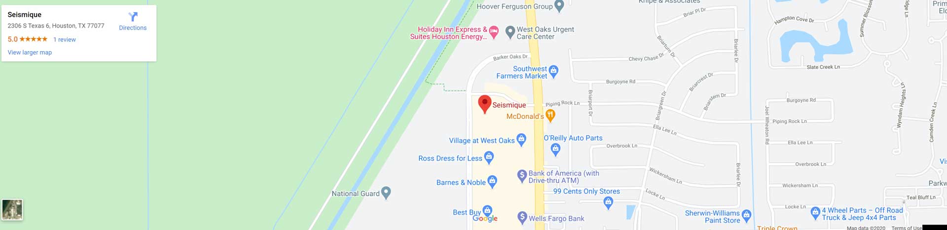
Earlier this week, a local redditor asked about a local business and included a link. Scrolling through their quite pretty website, I noticed something interesting. At the bottom was an embedded Google map. But it wasn't an embedded Google map.
It's an embeded screenshot of a Google map ([Original] / [Mirror]) which itself is a link to the location on Google Maps.
![[Original]](https://seismique.com/wp-content/uploads/2020/02/map.jpg)
![[Mirror]](https://files.seemsgood.net/seismique-map.jpg)
I think this is a pretty clever workaround. Most people visiting the site don't actually need to interact with the map and if they do, they're probably quite happy to do so on the Google website. However, the workaround has one limitation that is also the reason that I noticed it: resolution.
I use a 49" ultrawide monitor. While I'm not browsing the web with that full width, my browser is likely bigger than a lot of people's. I noticed the map because it was slightly blurry. Pulling the file down, I see that it's 1920 pixels wide (the width of the 1080p HD standard). The website's responsive design then automatically stretched that to fit my browser.
1080p is likely the highest resolution that the creator of this image could create. If you're going to use this workaround, maybe borrow someone's gigantic monitor to screenshot with. It's better to have a large image scaled down than the other way around.
There is a second problem, but it's non-technical. This is almost certainly against Google's terms. The bottom right of the image has a portion of the image blacked out. The Google Maps interface appears to have changed since this screenshot was taken, so I can't tell what used to be there. I would imagine that's something about how this image shouldn't be embedded.